


La Cime des Conchiers / Roche Chevalier (Version 2) 10 km - D.760 m

Thomasdanielle
User
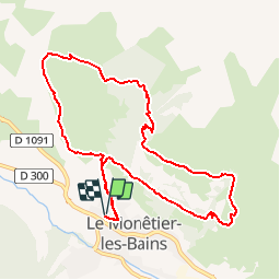

Length
10.4 km

Max alt
2147 m

Uphill gradient
761 m
Km-Effort
21 km

Min alt
1499 m

Downhill gradient
762 m
Boucle
Yes
Creation date :
2019-06-08 14:51:41.754
Updated on :
2019-06-08 15:24:26.383
4h04
Difficulty : Difficult

FREE GPS app for hiking
 SityTrail
IGN / Geographical institutes
SityTrail Plus
The world is yours!
About
Trail Walking of 10.4 km to be discovered at Provence-Alpes-Côte d'Azur, Hautes-Alpes, Le Monêtier-les-Bains. This trail is proposed by Thomasdanielle.
Description
D/A : idem version 1 sauf qu'au niveau du point 1 à gauche au lieu de droite
Positioning
Country:
France
Region :
Provence-Alpes-Côte d'Azur
Department/Province :
Hautes-Alpes
Municipality :
Le Monêtier-les-Bains
Location:
Unknown
Start:(Dec)
Start:(UTM)
303330 ; 4983559 (32T) N.
Comments